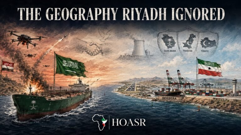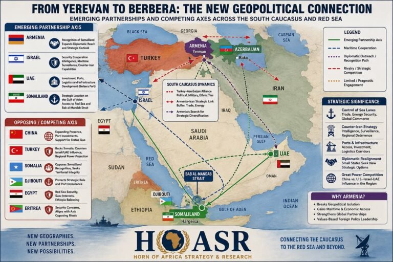
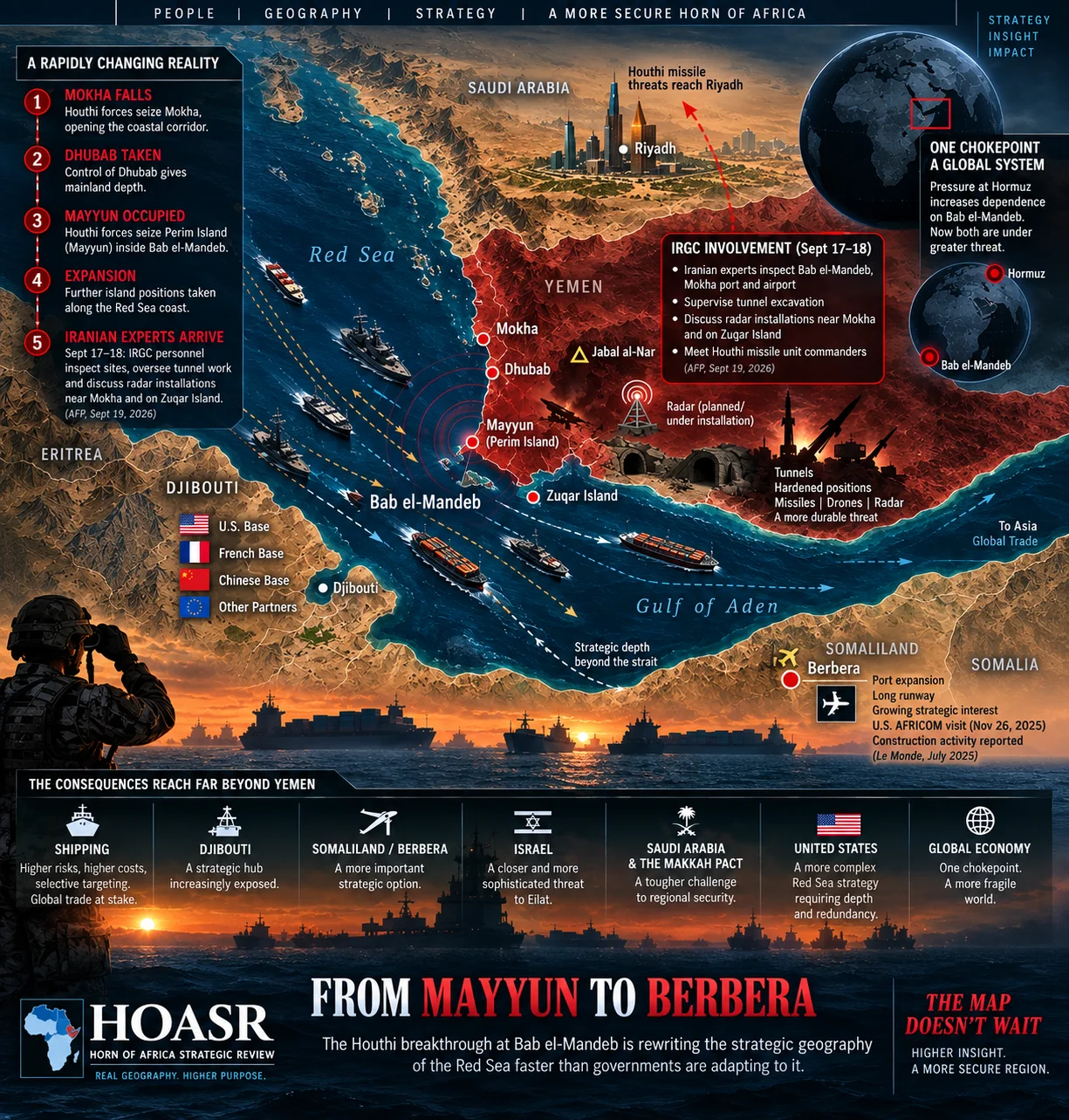
From Mayyun to Berbera, the changing military geography around Bab el-Mandeb is reshaping the strategic calculations of regional and international powers. Original HOASR infographic.
The Houthi advance at Bab el-Mandeb is changing the strategic geography of the Red Sea faster than governments and regional security arrangements are adapting to it.
The map changed in a matter of days. Houthi forces swept through positions held by Yemen’s internationally recognized government along the southern Red Sea coast, taking Mokha and Dhubab before reaching Mayyun, or Perim Island, inside the Bab el-Mandeb Strait. Their subsequent expansion onto other strategic Red Sea islands extended the territorial gains farther north.
The offensive moved the military center of gravity of the Yemen conflict toward one of the world’s most important maritime corridors. Reuters had warned as the offensive developed that control of the Yemeni Red Sea coast would substantially strengthen Houthi leverage over shipping through Bab El-Mandeb. The battlefield was no longer confined to Yemen’s mountains, cities and internal political struggle. It had arrived at the gateway connecting the Indian Ocean with the Red Sea and Suez Canal. [Reuters]
Now the story has moved another step. Reporting published on September 19 indicates that the Houthis are beginning to transform their newly captured geography into something potentially more durable. Two Houthi military sources told AFP that personnel from Iran’s Islamic Revolutionary Guard Corps (IRGC) visited Bab El-Mandeb, Mokha port and airport, and the former government command facility at Jabal al-Nar.
According to those sources, the Iranian specialists supervised tunnel excavation in hills overlooking Mokha and Bab El-Mandeb and discussed radar installations near Mokha and on Zuqar Island. The visits reportedly occurred separately on September 17 and 18, only days after the Houthi territorial breakthrough. If these preparations mature into an integrated network of hardened positions, radars, missiles and drones, the security problem at Bab El-Mandeb will have moved well beyond the initial seizure of territory. [AFP via Ahram Online]
Capturing Mayyun creates geographic advantage. Holding Dhubab provides mainland ground strength. Establishing radar positions on surrounding high ground and islands would improve the Houthis’ ability to build a reliable maritime picture of vessels entering and leaving the Red Sea.
Underground facilities could make important equipment and personnel more difficult to destroy from the air. Missiles and drones could then operate alongside surveillance systems rather than as isolated weapons. The result would begin to resemble a fortified maritime-denial environment positioned around one of global commerce’s narrowest gateways. AFP has not established that such a complete system is already operational, but the reported preparations indicate the direction in which Houthi military planning may be moving. [Asharq Al-Awsat / AFP]
From Territorial Breakthrough to Military Architecture
Mayyun is therefore more than another island captured in Yemen’s long war. It lies inside Bab el-Mandeb and divides the strait into two navigational channels, while Dhubab provides strategic depth from the adjacent Yemeni mainland. Positions farther north extend the Houthi presence into the southern Red Sea. Together, they offer substantially better opportunities to observe maritime traffic and potentially position drones, missiles, sensors and small craft closer to passing vessels.
That does not mean the Houthis have physically closed Bab El-Mandeb or acquired uncontested command of an international waterway. Commercial vessels continue to transit the strait. The Houthis are now increasingly positioned to observe and selectively threaten the traffic passing beside territory they now hold and, that is the strategic change. [DataPortuaria]
This is why the reported Iranian technical presence deserves particular attention. According to AFP’s sources, the IRGC personnel did not merely visit captured positions ceremonially. They reportedly examined radar deployment, met Houthi missile personnel and supervised work on underground facilities overlooking the maritime corridor. That suggests an effort to consolidate the breakthrough before Yemeni government forces can reverse it. Government-aligned forces are fighting around the Kahboub mountain region overlooking Bab El-Mandeb, and reporting on September 19 indicated continuing clashes there. The battlefield therefore remains fluid outside the core Houthi-held positions. The race is increasingly between a government counteroffensive and Houthi efforts to fortify what they have already captured. [Yemen Online]
A Second Choke-point Crisis
For several years, international responses to the Houthis concentrated primarily on missiles and drones launched against commercial and military vessels. The operational question was defensive: how could naval forces detect and intercept the next incoming weapon? Mayyun and Dhubab introduce a different problem because the challenge is becoming territorial as well as technological. Reuters describes Bab El-Mandeb as one of the world’s busiest and most contested maritime choke-points and notes that Houthi domination of the waterway would further isolate Gulf energy exporters from major shipping routes. Coastal control does not automatically translate into control of every ship crossing international waters. It does, however, improve the ability to monitor, threaten and selectively disrupt that traffic. [Reuters]
The development becomes more consequential when Bab El-Mandeb is considered together with the Strait of Hormuz. Pressure around Hormuz increases the importance of Saudi Arabia’s ability to move energy westward toward the Red Sea rather than relying exclusively on Gulf export routes. Bab el-Mandeb sits at the opposite end of that alternative maritime system. Iran exercises direct strategic leverage around Hormuz, while an Iran-aligned movement has now captured critical terrain around the southern entrance to the Red Sea. The two choke points should therefore no longer be viewed as completely separate theaters. Pressure at one increases dependence on the other. Pressure at both begins to affect the strategic architecture of the entire Arabian Peninsula.
The crisis is also expanding geographically. On September 19, Saudi Arabia confirmed that it intercepted a Houthi ballistic missile directed toward Riyadh, while the Houthis claimed additional attacks against Saudi energy and civilian infrastructure. The attack marked a further escalation beyond the fighting around Bab El-Mandeb and demonstrated that the movement is simultaneously contesting territory in Yemen, threatening maritime routes and projecting missile and drone power deep into Saudi Arabia. Saudi forces have intensified their response, but the Houthi advance has already exposed how difficult it is to reverse territorial gains once the movement has established itself. [Associated Press]
The Network Behind the Advance
Jonathan Spyer’s September 19 analysis in The Jerusalem Post adds another dimension to the breakthrough. He reports that documents obtained from Yemeni sources describe Iranian, Iraqi and Lebanese personnel contributing expertise to Houthi intelligence, missile and drone capabilities. The report also describes Russian communications technology and Chinese-origin electronics components within Houthi supply networks. Those allegations require independent corroboration, particularly where they concern named foreign personnel or government involvement.
The presence of Chinese- or Russian-manufactured equipment does not by itself establish Chinese or Russian state direction. But the subsequent AFP reporting of IRGC personnel inspecting Houthi positions provides separate reporting that Iranian technical involvement around the newly captured Red Sea territory is more than an abstract strategic relationship. [The Jerusalem Post]
The Houthis should nevertheless not be reduced simply to an Iranian instrument. They are an indigenous Yemeni movement with their own leadership, interests and strategic calculations. Iran did not need to explain the value of Mayyun to a movement that has fought across Yemen for decades. What external weapons, training and technical expertise can do is increase the Houthis’ ability to exploit geography they already understand.
Reuters notes that the movement has evolved from a relatively small northern insurgency into a large military organization with sophisticated missile and drone capabilities and longstanding Iranian and Hezbollah support. The danger at Bab el-Mandeb therefore comes from the combination of local territorial control and increasingly sophisticated external assistance. [Reuters]
The Coalition That Was Not Ready
The speed of the Houthi breakthrough exposed serious weaknesses among the forces opposing them. The Financial Times reports that fragmentation among government-aligned factions contributed to the collapse along the Red Sea front, while the offensive has produced one of the most serious setbacks Saudi Arabia has faced in Yemen in years. Anti-Houthi fighters abandoned positions as the offensive accelerated, and Saudi airstrikes have subsequently intensified in an effort to slow or reverse the gains.
The problem for Riyadh is that bombing advancing columns is different from removing a force once it has occupied islands, mountains and coastal infrastructure. If tunnels and surveillance positions are now being constructed, that challenge becomes even more harder. [Financial Times]
This is also becoming a test for the emerging regional security arrangements surrounding Saudi Arabia. The Makkah Pact between Saudi Arabia, Türkiye and Pakistan was designed to strengthen collective security, yet the Bab el-Mandeb crisis demonstrates the difference between political commitments and operational integration.
Intelligence sharing, maritime surveillance, air defense, logistics and coordinated command structures cannot be improvised after an opponent has already moved. The Houthis needed no multinational conference before occupying Mayyun. Their objective was geographic and immediate. Regional institutions now have to determine whether they can respond at the speed with which the battlefield has changed.
The Bureaucratic Gap
The contrast is increasingly stark. The Houthis captured strategic territory, moved personnel onto islands, occupied coastal installations and are now reportedly working with Iranian specialists on tunnels and radar positions. Western and regional governments, meanwhile, continue debating the appropriate level of response. Washington has approached renewed direct military involvement cautiously, while European states are reassessing maritime protection requirements. Saudi Arabia is carrying much of the immediate burden of containing the Houthi escalation. The political process moves through consultations, alliance management and legal authorities. Military geography moves when forces physically occupy the ground.
This does not mean governments should act without deliberation. Bab El-Mandeb sits inside an extraordinarily complicated strategic environment involving Yemen’s civil war, Saudi security, Iran, Israel, international shipping and competing foreign military presences across the African shore.
Poorly conceived intervention could deepen the conflict. But excessive delay carries its own strategic cost. Every additional week in which captured territory can be surveyed, tunneled, supplied and connected to surveillance systems makes eventual reversal more difficult. Bureaucratic caution can become strategically consequential when the adversary uses the time to alter the physical operating environment.
Europe Confronts the New Geography
European governments are already confronting that reality. Italy has called for additional naval protection in the Red Sea as insecurity around Bab El-Mandeb threatens commercial shipping and European access to the Suez route. Europe depends heavily on the corridor connecting the Indian Ocean, Red Sea, Suez Canal and Mediterranean. Naval deployments can protect individual ships and improve surveillance, but they cannot erase the advantage created when an armed movement occupies terrain overlooking a choke point.
Actual shipping data also requires caution against exaggeration. Recent vessel-tracking figures indicate that Bab El-Mandeb traffic has remained more resilient than might be expected from the headlines, with no sustained collapse in total crossings. That does not invalidate the strategic danger. It shows instead that control of strategic terrain and closure of an international waterway are not the same thing. The Houthis do not need to stop every ship to exercise leverage. Selective targeting, higher insurance costs, rerouting decisions and the threat of future escalations can produce strategic effects long before the waterway is physically closed. [DataPortuaria]
Across the Water: Djibouti
Follow the geography west from Mayyun and the next strategic landscape is Horn of Africa. Djibouti sits immediately across Bab el-Mandeb and hosts one of the densest concentrations of foreign military facilities in the world. American, Chinese, French and other forces operate from a small territory beside the shipping lanes entering and leaving the Red Sea. For decades, this concentration offered extraordinary strategic efficiency. The Houthi advance complicates that assumption. Djibouti becomes more valuable because the opposite shore has become more dangerous, but it also becomes more exposed because so much military infrastructure is concentrated within the same geographic space.
The possibility of Houthi radar infrastructure makes this calculation even more important. A persistent surveillance network around the Yemeni side of Bab el-Mandeb could potentially improve monitoring of maritime movements approaching or leaving Djibouti. The precise capability, range and sophistication of the systems under discussion have not been publicly established, so claims about what they can currently observe would be premature.
But military planners cannot ignore the possibility that captured high ground and islands could become sensor positions rather than simply infantry outposts. The strategic problem is therefore not only what weapons the Houthis possess. It is whether they are beginning to build the surveillance architecture necessary to use those weapons more effectively.
Then Comes Berbera
Several hundred kilometers east of Djibouti lies Berbera. For years, discussion of the Somaliland port has been dominated by recognition politics, commercial development and the unresolved dispute between Somaliland and Somalia. The emerging Red Sea security environment introduces another dimension.
Berbera lies farther east along the Gulf of Aden, outside the immediate Bab El-Mandeb corridor but close enough to support maritime surveillance, aviation, logistics and regional security operations. It combines a major port with an unusually long airfield originally developed during the Cold War. Geography that once made the city important to competing superpowers is again attracting attention.
American interest is documented. On November 26, 2025, U.S. Africa Command chief General Dagvin Anderson visited Somaliland and met President Abdirahman Mohamed Abdullahi and senior security officials. AFRICOM says Anderson and senior commanders subsequently traveled to Berbera specifically to “assess the security environment and review the port’s operational capacity.” That language comes directly from the U.S. military. It does not establish that Washington has decided to establish a military base in Berbera. It does establish that AFRICOM has formally examined Berbera as an operationally relevant location. [U.S. Africa Command]
Berbera Airport has simultaneously attracted international attention. A July investigation by Le Monde examined satellite imagery showing substantial construction and excavation south of the runway beginning in late 2025. The newspaper reported trenches and underground structures that security sources assessed as potentially associated with ammunition or fuel storage.
Le Monde attributed the construction to the UAE and reported claims from its sources that the facility was being developed with potential American and Israeli requirements in mind. Those are serious claims from a major international newspaper. They are not equivalent to independently verified evidence that U.S. or Israeli forces are presently based at Berbera. [Le Monde]
Mayyun Changes the Berbera Equation
Why is Berbera attracting a lot of attention. The answer is increasingly visible across the Gulf of Aden. At Bab El-Mandeb sits an increasingly capable Houthi force occupying strategic Yemeni coastal and island positions. Iranian specialists are now reported to have examined how radar and hardened infrastructure could be added to that geography. Across the water sits Djibouti, already crowded with foreign military installations. Farther east sits Berbera, combining a deep-water port, a long runway, expanding infrastructure and demonstrated American military interest. What once appeared to be a collection of separate locations increasingly resembles a single strategic corridor.
Before the seizure of Mayyun, Berbera could reasonably be described as an additional strategic option. After the Houthi breakthrough—and particularly after reports that the captured territory may be developed into a harder surveillance and military network—the logic of geographic redundancy becomes stronger. A second African-side location could potentially support intelligence, surveillance and reconnaissance, maritime-domain awareness, logistics, aviation and emergency access without concentrating every capability immediately opposite Bab El-Mandeb. None of this proves that Washington or Israel has decided to use Berbera for those purposes. It demonstrates why military planners would examine the possibility. The strategic inference becomes stronger as the security environment immediately around Djibouti becomes more contested.
Israel Looks South
Israel has an additional reason to study the same map. Maritime access to Eilat from the Indian Ocean requires passage through Bab El-Mandeb. Houthi possession of Mayyun therefore places an Iran-aligned armed movement directly beside the southern maritime gateway leading toward Israel’s Red Sea coast. The challenge becomes more serious if captured territory evolves into an integrated surveillance environment. Radar, drones, coastal observation and missile systems working together could improve the ability to identify, classify and selectively threaten shipping. A force does not need to sink every vessel to change commercial behavior.
Therefore, the African shore, specifically Berbera, offers the additional strategic importance necessary. Early warning, maritime intelligence and the ability to observe developments across the Gulf of Aden become more valuable as Houthi positions move closer to the shipping corridor and become more technically sophisticated. Somaliland’s relationship with Israel consequently intersects with geography in ways that extend beyond diplomacy. That still does not establish an Israeli military deployment at Berbera. It means the incentives for intelligence and security cooperation are growing as the threat environment changes.
The Red Sea Is Becoming One Strategic System
A major mistake now would be to examine Hormuz, Mayyun, Dhubab, Djibouti, Berbera, Eilat and Saudi Arabia as separate stories. They are increasingly components of the same security architecture. When Hormuz becomes dangerous, Saudi Arabia depends more heavily on alternatives toward the Red Sea. When Bab El-Mandeb becomes dangerous, commercial shipping demands naval protection. When the Yemeni coastline becomes militarized, the opposite African shore becomes more important. When surveillance infrastructure begins appearing around the chokepoint, distance and redundancy acquire additional value. And when an armed movement occupies an island inside the waterway itself, ports and airfields previously regarded as marginal begin to look different.
Meanwhile, The U.S. and Israel are watching the situation closely. Regional security requirements are beginning to move toward Berbera as a strategic hot spot because circumstances elsewhere are pushing them in that direction. AFRICOM examined Berbera long before the current Houthi breakthrough. Construction at Berbera Airport also predates Mayyun’s fall. The present crisis did not suddenly create strategic interest in Berbera. It has made the logic behind that interest considerably easy to understand. And much easier to also understand the widespread speculation about U.S. and Israel potential basing at Berbera.
The Scoop:
The fall of Mayyun was the first warning. The reported arrival of Iranian specialists to examine radar positions and supervise tunneling is the second. The strategic warning clearly indicates that the Houthis not only simply captured important territory during a rapid offensive. The ral strategic danger is that they may now have the time, external expertise and geographic position required to transform that territory into something harder to remove: a fortified surveillance and maritime-denial belt overlooking Bab El-Mandeb. [AFP via Ahram Online]
If that architecture takes shape, the implications will extend far beyond Yemen. Saudi Arabia will confront an entrenched adversary near the outlet of its Red Sea energy corridor. Israel will face a more sophisticated threat along the maritime route toward Eilat.
Djibouti will remain indispensable but will sit opposite an increasingly militarized coastline. European navies will confront a security problem that escorts alone cannot solve. Washington will have to reconsider whether a Red Sea strategy concentrated heavily around one African location provides sufficient strategy for the environment now emerging.
Somaliland has not moved on the map and reports of American or Israeli military involvement there remain speculative without evidence. But Berbera will look different because the strategic environment around it has moved. Mayyun has changed hands. Dhubab has changed hands. Iranian specialists are reportedly examining how the new Houthi positions can be hardened and connected to surveillance systems. The military geography north of the Gulf of Aden is being rewritten while the diplomatic architecture on its southern shore remains largely anchored to older assumptions.
There is still time for the Houthi gains to be reversed. Yemeni government and allied forces continue fighting around the approaches to Bab El-Mandeb, and possession of captured territory does not guarantee permanent control. Nor should governments rush into a wider war simply because the map has changed. But there is a difference between strategic restraint and strategic inertia.
Restraint preserves options. Inertia allows an opponent to dig tunnels, install sensors, reinforce islands and turn yesterday’s battlefield advance into tomorrow’s military infrastructure.
That is the danger now emerging at Bab El-Mandeb. Will Washington, Riyadh, Jerusalem and their partners respond quickly now while the new geography remains reversible—or wait until it has been fortified into a permanent feature of the Red Sea. The bureaucracy can still say wait. But the Houthis are digging in deep. And the geopolitical map is already moving. HOASR WEEKLY REVIEW | The Houthis Hold the Choke Point and Somaliland Must Move

Prof. Nassir Hussein Kahin is a researcher, educator, journalist, and geopolitical analyst specializing in the Horn of Africa, the Red Sea, international law, diplomacy, and strategic affairs. To read Full Bio click on this link: ABOUT THE AUTHORProf. Nassir Hussein Kahin